


Select Category


Brands

Blue Sea Systems 4306 Weatherdeck 12V Dc 6 Position Waterproof Fuse Panel, Gray - 4306-Bss - 661-4306F1
Water resistant to IP67. Constructed from corrosion resistant materials. Concealed mounting screw holes. Integrated switch guards prevent accidental switching. UV tested faceplate. Rugged UV rated waterproof boots. Panel can be mounted in four different orientations. Illuminated circuit labels provide visibility in low light conditions. Bi-colored LED's. Panel cumulative rating of 45 amperes.
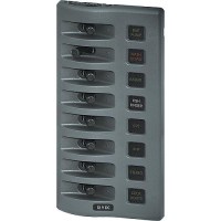
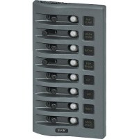
Blue Sea Systems 4308 Weatherdeck 12V Dc 8 Position Waterproof Fuse Panel, Gray - 4308-Bss - 661-4308F1
Water resistant to IP67. Constructed from corrosion resistant materials. Concealed mounting screw holes. Integrated switch guards prevent accidental switching. UV tested faceplate. Rugged UV rated waterproof boots. Panel can be mounted in four different orientations. Illuminated circuit labels provide visibility in low light conditions. Bi-colored LED's. Panel cumulative rating of 45 amperes.
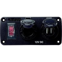
Blue Sea Systems 4363 Water-Resistant Usb Accessory Panel, W/12V Socket, 2.1A Dual Usb Charger - 4363-Bss - 661-4363F1
Easy to install accessory panel includes a 15A circuit breaker switch and pre-wired harness. Pre-wired harness included for easy installationSilicon breaker boots and gasket protects against water ingressIlluminated Carling Technologies 15A circuit breaker switch allows the ability to shut off panel preventing parasitic drawPolycarbonate/ABS panel face is UV-stabilized, flame retardant, and will not corrode12V DC only
Blue Sea Systems 4365 Water-Resistant Usb Accessory Panel, W/12V Socket, 2 X 2.1A Dual Usb Charger - 4365-Bss - 661-4365F1
Easy to install accessory panel includes a 15A circuit breaker switch and pre-wired harness. Pre-wired harness included for easy installationSilicon breaker boots and gasket protects against water ingressIlluminated Carling Technologies 15A circuit breaker switch allows the ability to shut off panel preventing parasitic drawPolycarbonate/ABS panel face is UV-stabilized, flame retardant, and will not corrode12V DC only
Blue Sea Systems 4378 Weatherdeck 12V Dc 8 Position Waterproof Circuit Breaker Panel, Gray - 4378-Bss - 661-4378F1
Designed for flybridge and open cockpit applications. For 12 or 24 V systems. Constructed from corrosion resistant materials, the panel front withstands rain, sea spray, and hose spray wash down. Independent label backlighting circuit for remote switching and dimming. Compatible with all BSS digital dimmers. Rugged UV stabilized waterproof boots protect toggle switches and push button thermal circuit breakers.
Blue Sea Systems 5023 St-Blade Battery Terminal Mount Fuse Block - 5023-Bss - 661-5023F1
Easy to install 4 ATO®/ATC® fused circuits mounts directly on the battery terminal studs. Screw terminals for securing wires with ring terminals and insulating covers included. Screw terminals for securing wiresAccepts small format circuit labelsInsulating cover meets ABYC/USCG insulation requirementsIgnition Protected - for use in a gasoline engine compartmentIncludes 4 write-on circuit labelsIncludes four 16-14 AWG and four 12-10 AWG Nylon insulated ring terminalsFuses sold separately
Blue Sea Systems 5024 St-Blade Battery Terminal Mount Fuse Block Kit W/Negative Busbar - 5024-Bss - 661-5024F1
Easy to install 4 ATO®/ATC® fused circuits mounts directly on the battery terminal studs. Screw terminals for securing wires with ring terminals and insulating covers included. Screw terminals for securing wiresAccepts small format circuit labelsInsulating cover meets ABYC/USCG insulation requirementsIgnition Protected - for use in a gasoline engine compartmentIncludes 4 write-on circuit labelsIncludes four 16-14 AWG and four 12-10 AWG Nylon insulated ring terminalsFuses sold separately 5024 includes a 4-circuit negative busbar
Blue Sea Systems 5025 St Blade Common Source Ato/Atc Fuse Block W/Negative Bus - 6 Circuits With Cover - 5025-Bss - 661-5025F1
Clear insulating cover with label recess for small Blue Sea Systems' labels. Cover insulates all conductive parts, satisfying ABYC/USCG requirements. Tin-plated copper buses and fuse clips give 30 Ampere rating per circuit. Rated for 32 Volts DC, 100 Ampere maximum per block. Accepts ATO and ATC fast acting blade type fuses and plug-in style circuit breakers. Thermoplastic base and polycarbonate cover.
Blue Sea Systems 5026 St Blade Common Source Ato/Atc Fuse Block W/Negative Bus - 12 Circuits With Cover - 5026-Bss - 661-5026F1
Clear insulating cover with label recess for small Blue Sea Systems' labels. Cover insulates all conductive parts, satisfying ABYC/USCG requirements. Tin-plated copper buses and fuse clips give 30 Ampere rating per circuit. Rated for 32 Volts DC, 100 Ampere maximum per block. Accepts ATO and ATC fast acting blade type fuses and plug-in style circuit breakers. Thermoplastic base and polycarbonate cover.
Blue Sea Systems 5028 St Blade Common Source Ato/Atc Fuse Block - 6 Circuits With Cover - 5028-Bss - 661-5028F1
Clear insulating cover with label recess for small Blue Sea Systems' labels. Cover insulates all conductive parts, satisfying ABYC/USCG requirements. Tin-plated copper buses and fuse clips give 30 Ampere rating per circuit. Rated for 32 Volts DC, 100 Ampere maximum per block. Accepts ATO and ATC fast acting blade type fuses and plug-in style circuit breakers. Thermoplastic base and polycarbonate cover.
Blue Sea Systems 5029 St Blade Common Source Ato/Atc Fuse Block - 12 Circuits With Cover - 5029-Bss - 661-5029F1
Clear insulating cover with label recess for small Blue Sea Systems' labels. Cover insulates all conductive parts, satisfying ABYC/USCG requirements. Tin-plated copper buses and fuse clips give 30 Ampere rating per circuit. Rated for 32 Volts DC, 100 Ampere maximum per block. Accepts ATO and ATC fast acting blade type fuses and plug-in style circuit breakers. Thermoplastic base and polycarbonate cover.
Blue Sea Systems 5030 St Blade Common Source Ato/Atc Fuse Block W/Negative Bus - 6 Circuits - 5030-Bss - 661-5030F1
Tin-plated copper buses and fuse clips give 30 Ampere rating per circuit. Rated for 32 Volts DC, 100 Ampere maximum per block. Accepts ATO and ATC fast acting blade type fuses and plug-in style circuit breakers. Thermoplastic base and polycarbonate cover.
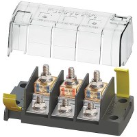
Blue Sea Systems 5194 Independent Source Fuse Bock - 5194-Bss - 661-5194F1
Surface mount fuse blocks accommodate three MRBF fuses for consolidated high amperage circuit protection The independent source fuse block (5194) is ideal for 3 output battery chargersClip-on cover insulates terminal connectionsVersatile wiring options allow all wires to come out a single sideLabel recesses for easy circuit identificationOne-piece stainless flange nuts ensure safe and secure connectionsIgnition protected when used with MRBF fusesFuses sold separately Specifications:Voltage Max. Operating: 58V DCAmperage Max. Operating: 240A per circuitTerminal Fuses Available: 30-300 Amps
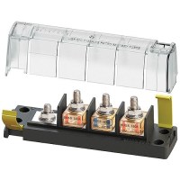
Blue Sea Systems 5196 Common Source Fuse Bock - 5196-Bss - 661-5196F1
Surface mount fuse blocks accommodate three MRBF fuses for consolidated high amperage circuit protection The common source fuse block (5196) provides 3 loads from a single sourceClip-on cover insulates terminal connectionsVersatile wiring options allow all wires to come out a single sideLabel recesses for easy circuit identificationOne-piece stainless flange nuts ensure safe and secure connectionsIgnition protected when used with MRBF fusesFuses sold separately Specifications:Voltage Max. Operating: 58V DCAmperage Max. Operating: 240A per circuitTerminal Fuses Available: 30-300 Amps
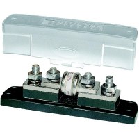
Blue Sea Systems 5502 Class T Fuse Block With Insulating Cover - 225 To 400A - 5502-Bss - 661-5502F1
Recommended for high speed circuit protection of electronic equipment such as inverters. Tin-plated copper bus and stainless steel hardware. 3/8" (M10) stud terminals. Clear insulation cover with breakouts allow cable access from all directions. Maximum ratings: 160 Volts DC.
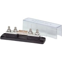
Blue Sea Systems 5503 Anl Fuse Block With Insulating Cover - 35 To 750A - 5503-Bss - 661-5503F1
Accepts wide range of ANL Fuse amperages for a versatile ignition protected fusing system. Tin-plated copper bus and stainless steel hardware. A 5/16" (M8) stud terminals. Insulation cover with breakouts allow cable access from all directions. Maximum rating: 32 Volts DC.
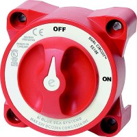
Blue Sea Systems 5510E E-Series Dual Circuit Battery Switch - 5510E-Bss - 661-5510Ef1
Switches both positive and negative lines simultaneously with one simple ON/OFF switch meeting European and metal boat requirements for a double pole switchSwitches circuits of different voltages, such as 12 Volt and 24 Volt, simultaneously with one simple ON/OFF switchRated for 350 amps coninuous, 525 intermittent, 1000 cranking.
Blue Sea Systems 5511E E-Series Dual Circuit Plus Battery Switch - 5511E-Bss - 661-5511Ef1
Switches two battery banks simultaneously with one ON/OFF switch while maintaining battery bank isolation, minimizing the risk of a dead start batteryThe "combine batteries" function offers the ability to combine the two battery banks in the event of a low start batteryRated for 350 amps continuous, 525 intermittent, 1000 cranking.
Blue Sea Systems 7036 187 Series Dc Circuit Breaker - Panel Mount, 30 Amps - 7036-Bss - 661-7036F1
Heavy duty circuit protection when switching and circuit protection are both required. Single lever operation is clearly visible. Ignition protected (conforming to SAE J1171), safe for installation aboard gas-powered boats. Weather resistant. 5/16-18 terminal studs. Maximum voltage 42 volts DC.
Blue Sea Systems 7038 187 Series Dc Circuit Breaker - Panel Mount, 40 Amps - 7038-Bss - 661-7038F1
Heavy duty circuit protection when switching and circuit protection are both required. Single lever operation is clearly visible. Ignition protected (conforming to SAE J1171), safe for installation aboard gas-powered boats. Weather resistant. 5/16-18 terminal studs. Maximum voltage 42 volts DC.
Blue Sea Systems 7039 187 Series Dc Circuit Breaker - Panel Mount, 50 Amps - 7039-Bss - 661-7039F1
Heavy duty circuit protection when switching and circuit protection are both required. Single lever operation is clearly visible. Ignition protected (conforming to SAE J1171), safe for installation aboard gas-powered boats. Weather resistant. 5/16-18 terminal studs. Maximum voltage 42 volts DC.
Blue Sea Systems 7040 187 Series Dc Circuit Breaker - Panel Mount, 60 Amps - 7040-Bss - 661-7040F1
Heavy duty circuit protection when switching and circuit protection are both required. Single lever operation is clearly visible. Ignition protected (conforming to SAE J1171), safe for installation aboard gas-powered boats. Weather resistant. 5/16-18 terminal studs. Maximum voltage 42 volts DC.
Blue Sea Systems 7042 187 Series Dc Circuit Breaker - Panel Mount, 80 Amps - 7042-Bss - 661-7042F1
Heavy duty circuit protection when switching and circuit protection are both required. Single lever operation is clearly visible. Ignition protected (conforming to SAE J1171), safe for installation aboard gas-powered boats. Weather resistant. 5/16-18 terminal studs. Maximum voltage 42 volts DC.
Blue Sea Systems 7044 187 Series Dc Circuit Breaker - Panel Mount, 100 Amps - 7044-Bss - 661-7044F1
Heavy duty circuit protection when switching and circuit protection are both required. Single lever operation is clearly visible. Ignition protected (conforming to SAE J1171), safe for installation aboard gas-powered boats. Weather resistant. 5/16-18 terminal studs. Maximum voltage 42 volts DC.
Blue Sea Systems 7046 187 Series Dc Circuit Breaker - Panel Mount, 120 Amps - 7046-Bss - 661-7046F1
Heavy duty circuit protection when switching and circuit protection are both required. Single lever operation is clearly visible. Ignition protected (conforming to SAE J1171), safe for installation aboard gas-powered boats. Weather resistant. 5/16-18 terminal studs. Maximum voltage 42 volts DC.