
Garmin
Threaded Power/Data Cable 4Pin - 010-12445-00 - 322-0101244500F1
Vision Card, Jacksonville-Key West - 010-C0710-00 - 322-010C071000F1
See your precise, on-chart position in relation to navaids, coastal features and restricted areas with premium features found in this detailed marine mapping data. Includes all of the features of our BlueChart® g3 product and more. Shaded depth contours, coastlines, spot soundings, navaids, port plans, wrecks, obstructions, intertidal zones, restricted areas and IALA symbols.Seamless transitions between zoom levels and more continuity across chart boundaries.High resolution satellite imagery for a realistic view of the land and water.Aerial photos of ports, harbors, marinas, waterways, navigational landmarks and other POIs.Auto Guidance technology searches chart data to suggest the best passage to a destination.Mariner Eye View 3-D perspective for a quick, easy position fix.FishEye View 3-D perspective for an underwater view of the sea floor.Safety Shading enables contour shading for all depth contours shallower than your defined safe depths.Fishing Charts to scope out bottom contours and depth soundings with less visual clutter on the display.
Vision Card, Morgan City-Brownsville - 010-C0715-00 - 322-010C071500F1
See your precise, on-chart position in relation to navaids, coastal features and restricted areas with premium features found in this detailed marine mapping data. Includes all of the features of our BlueChart® g3 product and more. Shaded depth contours, coastlines, spot soundings, navaids, port plans, wrecks, obstructions, intertidal zones, restricted areas and IALA symbols.Seamless transitions between zoom levels and more continuity across chart boundaries.High resolution satellite imagery for a realistic view of the land and water.Aerial photos of ports, harbors, marinas, waterways, navigational landmarks and other POIs.Auto Guidance technology searches chart data to suggest the best passage to a destination.Mariner Eye View 3-D perspective for a quick, easy position fix.FishEye View 3-D perspective for an underwater view of the sea floor.Safety Shading enables contour shading for all depth contours shallower than your defined safe depths.Fishing Charts to scope out bottom contours and depth soundings with less visual clutter on the display.
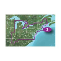
Vision Card, New York-Chesapeake - 010-C1004-00 - 322-010C100400F1
See your precise, on-chart position in relation to navaids, coastal features and restricted areas with premium features found in this detailed marine mapping data. Includes all of the features of our BlueChart® g3 product and more. Shaded depth contours, coastlines, spot soundings, navaids, port plans, wrecks, obstructions, intertidal zones, restricted areas and IALA symbols.Seamless transitions between zoom levels and more continuity across chart boundaries.High resolution satellite imagery for a realistic view of the land and water.Aerial photos of ports, harbors, marinas, waterways, navigational landmarks and other POIs.Auto Guidance technology searches chart data to suggest the best passage to a destination.Mariner Eye View 3-D perspective for a quick, easy position fix.FishEye View 3-D perspective for an underwater view of the sea floor.Safety Shading enables contour shading for all depth contours shallower than your defined safe depths.Fishing Charts to scope out bottom contours and depth soundings with less visual clutter on the display.
Vision Card, Tampa-New Orleans - 010-C0713-00 - 322-010C071300F1
See your precise, on-chart position in relation to navaids, coastal features and restricted areas with premium features found in this detailed marine mapping data. Includes all of the features of our BlueChart® g3 product and more. Shaded depth contours, coastlines, spot soundings, navaids, port plans, wrecks, obstructions, intertidal zones, restricted areas and IALA symbols.Seamless transitions between zoom levels and more continuity across chart boundaries.High resolution satellite imagery for a realistic view of the land and water.Aerial photos of ports, harbors, marinas, waterways, navigational landmarks and other POIs.Auto Guidance technology searches chart data to suggest the best passage to a destination.Mariner Eye View 3-D perspective for a quick, easy position fix.FishEye View 3-D perspective for an underwater view of the sea floor.Safety Shading enables contour shading for all depth contours shallower than your defined safe depths.Fishing Charts to scope out bottom contours and depth soundings with less visual clutter on the display.