

Select Category
General
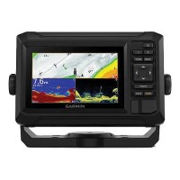
Garmin 0100258900 Echomap™ 5" Uhd2 52Cv Chartplotter/Sonar, W/O Tanducer W/Worldwide Basemap - 010-02589-00 - 322-0100258900F1
They say locals know best. But anyone who says that hasn't fished with the ECHOMAP UHD2 chartplotters with clear, crisp sonar and mapping. SONAR SUPPORT: With crisp, clear traditional sonar and brilliant ClearVü sonar, the fish will have nowhere to hide.VIVID COLOR PALETTES: High-contrast vivid scanning sonar color palettes make it easier than ever to distinguish targets and structureOPTIONAL TRANSDUCER: Your ECHOMAP UHD2 device supports a variety of Garmin transducers for two types of sonar: Garmin traditional and ClearVü scanning sonarsPRELOADED CHARTS: Know the waters you're in as if you grew up fishing them by using built-in worldwide basemap with support for Garmin Navionics+™ and Garmin Navionics Vision+™ marine cartographyWIRELESS NETWORKING: If you have another compatible ECHOMAP UHD2 chartplotter on your boat, the 5" and 7" models can wirelessly share information - such as sonar, waypoints and routes - with themACTIVECAPTAIN® APP: Built-in Wi-Fi connectivity pairs with the free all-in-one mobile app for access to the OneChart™ feature, software updates, Garmin Quickdraw™ Community data and more
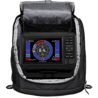
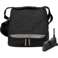
Garmin 0100259235 Echomap™ Uhd2 55Cv Ice Fishing Bundle W/Navionics+ Canada Inland & Coastal Charts - 010-02592-35 - 322-0100259235F1
Provides detailed maps and sonar to transform your fishing experience. Bright 5" display is sunlight readableDual Beam-IF ice fishing transducer with selectable beam widthBuilt-in flasher provides accurate jig and fish detectionCreate custom pages that combine sonar, flasher and mapSupports ClearVü scanning sonar for open water. Get nearly photographic images of what's below the surface (transducer sold separately)Rugged, portable carrying case^In The Box: Chartplotter, Dual Beam-IF transducer, Power cable, Tilt/swivel mount, Bag with handle, Foam float, Rechargeable battery & charger.
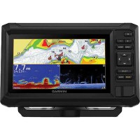
Garmin 0100259300 Echomap™ 7" Uhd2 72Cv Chartplotter/Sonar, W/O Tanducer W/Worldwide Basemap - 010-02593-00 - 322-0100259300F1
They say locals know best. But anyone who says that hasn't fished with the ECHOMAP UHD2 chartplotters with clear, crisp sonar and mapping. SONAR SUPPORT: With crisp, clear traditional sonar and brilliant ClearVü sonar, the fish will have nowhere to hide.VIVID COLOR PALETTES: High-contrast vivid scanning sonar color palettes make it easier than ever to distinguish targets and structureOPTIONAL TRANSDUCER: Your ECHOMAP UHD2 device supports a variety of Garmin transducers for two types of sonar: Garmin traditional and ClearVü scanning sonarsPRELOADED CHARTS: Know the waters you're in as if you grew up fishing them by using built-in worldwide basemap with support for Garmin Navionics+™ and Garmin Navionics Vision+™ marine cartographyWIRELESS NETWORKING: If you have another compatible ECHOMAP UHD2 chartplotter on your boat, the 5" and 7" models can wirelessly share information - such as sonar, waypoints and routes - with themACTIVECAPTAIN® APP: Built-in Wi-Fi connectivity pairs with the free all-in-one mobile app for access to the OneChart™ feature, software updates, Garmin Quickdraw™ Community data and more
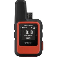
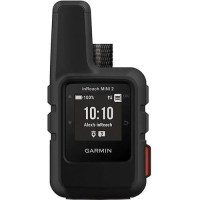
Garmin 0100260200 Inreach® Mini 2 Satellite Communicator, Red - 010-02602-00 - 322-0100260200F1
HOME IS CLOSER THAN YOU THINK!This compact satellite communicator helps you keep home with you when you're off the grid - adding peace of mind to every adventure, without adding weight to your pack. Small, rugged, lightweight 4" x 2" & 3.5 oz, impact resistant (MIL-STD-810) and water-rated to IPX7Global satellite coverage keeps you connected when cellphones can'tIn an emergency, send an interactive SOS messageShare your location with loved ones back homeConnect to the ones who matter, even without cellphone coverageTracBack® routing & digital compass, find your way back if you happen to get lostExpand the capabilities of your inReach device by using the Garmin Explore™ appUp to 14 days of battery life in 10-minute tracking mode In the Box: inReach Mini 2, USB cable, Carabiner, DocumentationSome features require subscription. See Garmin website for full product details.
Garmin 0100260201 Inreach® Mini 2 Satellite Communicator, Black - 010-02602-01 - 322-0100260201F1
HOME IS CLOSER THAN YOU THINK!This compact satellite communicator helps you keep home with you when you're off the grid - adding peace of mind to every adventure, without adding weight to your pack. Small, rugged, lightweight 4" x 2" & 3.5 oz, impact resistant (MIL-STD-810) and water-rated to IPX7Global satellite coverage keeps you connected when cellphones can'tIn an emergency, send an interactive SOS messageShare your location with loved ones back homeConnect to the ones who matter, even without cellphone coverageTracBack® routing & digital compass, find your way back if you happen to get lostExpand the capabilities of your inReach device by using the Garmin Explore™ appUp to 14 days of battery life in 10-minute tracking mode In the Box: inReach Mini 2, USB cable, Carabiner, DocumentationSome features require subscription. See Garmin website for full product details.
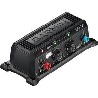
Garmin 0100261300 Bluenet™ 30 Gateway - 010-02613-00 - 322-0100261300F1
The Garmin BlueNet 30 gateway is required for Garmin BlueNet™ network compatible devices to network with legacy Garmin marine devices. Through this gateway you can connect a Garmin BlueNet network to a legacy Garmin Marine Network for a premium control experience. You will only need one gateway to connect the two networks.
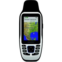
Garmin 0100263500 Gps 79S Floating Handheld Gps - 010-02635-00 - 322-0100263500F1
Stay on course, and track more adventures with our rugged, floating handheld. Floats, water-resistant (IPX7)Up to 19 hours of battery life in GPS tracking modeHigh-resolution color display you can read in the sunSupport for multiple satellite constellations - such as GPS, GLONASS, Galileo, QZSS and SBASSave and track 10,000 waypoints, 250 routes and 300 fitness activity filesBuilt-in 3-axis tilt-compensated electronic compass
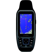
Garmin 0100263502 Gps 79Sc Floating Handheld Gps W/Bluechart G3 Coastal Charts - 010-02635-02 - 322-0100263502F1
Stay on course, and track more adventures with our rugged, floating handheld. Floats, water-resistant (IPX7)Up to 19 hours of battery life in GPS tracking modeHigh-resolution color display you can read in the sunSupport for multiple satellite constellations - such as GPS, GLONASS, Galileo, QZSS and SBASSave and track 10,000 waypoints, 250 routes and 300 fitness activity filesBuilt-in 3-axis tilt-compensated electronic compass
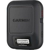
Garmin 0100267200 Inreach® Messenger - 010-02672-00 - 322-0100267200F1
If you're venturing off the grid, this small, rugged satellite communicator goes beyond the limits of cellular networks to keep friends and family in reach with global two-way text messaging. You can still connect to the ones who matter, even when there's no cellphone coveragePair your inReach device with the Garmin Messenger™ app on your compatible smartphone to text via satellite or cellular networksNeed emergency assistance? Send an interactive SOS to the Garmin coordination centerWhen you need to be sure, the on-device display confirms that your message has been sentUse check-in messages to easily check in with contacts as you travelStay on your adventures longer with up to 28 days of battery life between recharges
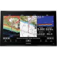
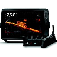
Garmin 0100267301 Gpsmap® 9219 19" 4K Premium Chartplotter W/Navionics+ Inland & Coastal Charts - 010-02673-01 - 322-0100267301F1
The industry's first integrated 4K resolution touchscreen chartplotter. Enjoy edge-to-edge clarity and luxury on a glass helm with premium design and materials plus enhanced connectivity and speed. Processing power is 7 times faster than previous generations for superior performanceBluenet Network; Build extensive networks with multiple chartplotters, cameras, radars and sonarsEnjoy audio and video integrations that allow you to show and hear the same video throughout the screens and speakers on your networkHigh-Definition Sonar; Fish in stunning high definition. Hook up to any of our sonar modules, and view sonar targets on the 4K display (transducers sold separately)Digital system integrations to monitor, automate and control your vessel. The chartplotter uses the NMEA 2000® and NMEA 0183 networks to connect to your compatible accessoriesGet wireless software updates via the ActiveCaptain® app with your compatible smartphone or tabletEngine Monitoring; Keep tabs on engine performance with extensive engine integration
Garmin 0100267401 Gpsmap® 9222 22" 4K Premium Chartplotter W/Navionics+ Inland & Coastal Charts - 010-02674-01 - 322-0100267401F1
The industry's first integrated 4K resolution touchscreen chartplotter. Enjoy edge-to-edge clarity and luxury on a glass helm with premium design and materials plus enhanced connectivity and speed. Processing power is 7 times faster than previous generations for superior performanceBluenet Network; Build extensive networks with multiple chartplotters, cameras, radars and sonarsEnjoy audio and video integrations that allow you to show and hear the same video throughout the screens and speakers on your networkHigh-Definition Sonar; Fish in stunning high definition. Hook up to any of our sonar modules, and view sonar targets on the 4K display (transducers sold separately)Digital system integrations to monitor, automate and control your vessel. The chartplotter uses the NMEA 2000® and NMEA 0183 networks to connect to your compatible accessoriesGet wireless software updates via the ActiveCaptain® app with your compatible smartphone or tabletEngine Monitoring; Keep tabs on engine performance with extensive engine integration
Garmin 0100267501 Gpsmap® 9224 24" 4K Premium Chartplotter W/Navionics+ Inland & Coastal Charts - 010-02675-01 - 322-0100267501F1
The industry's first integrated 4K resolution touchscreen chartplotter. Enjoy edge-to-edge clarity and luxury on a glass helm with premium design and materials plus enhanced connectivity and speed. Processing power is 7 times faster than previous generations for superior performanceBluenet Network; Build extensive networks with multiple chartplotters, cameras, radars and sonarsEnjoy audio and video integrations that allow you to show and hear the same video throughout the screens and speakers on your networkHigh-Definition Sonar; Fish in stunning high definition. Hook up to any of our sonar modules, and view sonar targets on the 4K display (transducers sold separately)Digital system integrations to monitor, automate and control your vessel. The chartplotter uses the NMEA 2000® and NMEA 0183 networks to connect to your compatible accessoriesGet wireless software updates via the ActiveCaptain® app with your compatible smartphone or tabletEngine Monitoring; Keep tabs on engine performance with extensive engine integration
Garmin 0100267601 Gpsmap® 9227 27" 4K Premium Chartplotter W/Navionics+ Inland & Coastal Charts - 010-02676-01 - 322-0100267601F1
The industry's first integrated 4K resolution touchscreen chartplotter. Enjoy edge-to-edge clarity and luxury on a glass helm with premium design and materials plus enhanced connectivity and speed. Processing power is 7 times faster than previous generations for superior performanceBluenet Network; Build extensive networks with multiple chartplotters, cameras, radars and sonarsEnjoy audio and video integrations that allow you to show and hear the same video throughout the screens and speakers on your networkHigh-Definition Sonar; Fish in stunning high definition. Hook up to any of our sonar modules, and view sonar targets on the 4K display (transducers sold separately)Digital system integrations to monitor, automate and control your vessel. The chartplotter uses the NMEA 2000® and NMEA 0183 networks to connect to your compatible accessoriesGet wireless software updates via the ActiveCaptain® app with your compatible smartphone or tabletEngine Monitoring; Keep tabs on engine performance with extensive engine integration
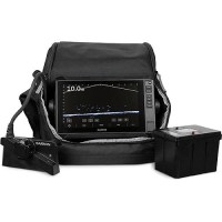
Garmin 0100269035 Livescope™ Plus Ice Fishing Bundle W/Navionics Canada Inland & Coastal Charts - 010-02690-35 - 322-0100269035F1
Includes ECHOMAP™ UHD2 95sv, LiveScope Plus System & Lithium-ion Battery.Get improved resolution, reduced noise, clearer images and better target separation with the LiveScope™ Plus Ice Fishing Bundle LI. It includes a 9-inch ECHOMAP™ UHD2 combo, the complete LiveScope Plus System with LVS34-IF transducer, swivel pole mount and a lightweight lithium battery. Revolutionary real-time sonar pairs with a large 9-inch ECHOMAP UHD2 combo touchscreen display with keyed assist, allowing you to see up to 200' in any directionOffers two live-scanning sonar modes - Down and Forward. It features a transducer cable that stays flexible, even in freezing conditionsPreloaded Garmin Navionics+ maps for exceptional detailYou can create custom pages that combine sonar, flasher and map on your displayFish even longer with a lightweight 16.5Ah lithium battery that won't weigh you down on the iceLiveScope Forward sonar shows up to 200' all around you and below the iceLiveScope Down sonar shows live sonar images of what is below the iceRugged, portable carrying case lets you easily transport it from hole to hole
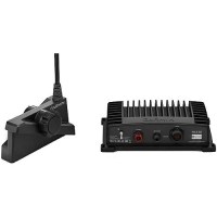
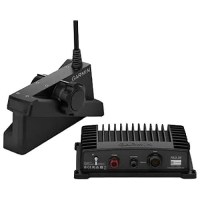
Garmin 0100270600 Livescope™ Plus System - 010-02706-00 - 322-0100270600F1
See images clearly with improved screen clarity, transducer sensitivity and target separationScan surroundings with sharper images, reduced noise and fewer sonar artifactsUpgrade your current LiveScope System black box (GLS™ 10 sonar module) with just a new transducerGet maximum contrast and clarity in your images with vivid color palettesDon't miss a thing with supported Forward, Down and Perspective modes and necessary mount 0100270600 System Includes: LiveScope GLS 10 sonar black box, LiveScope Plus LVS34 transducer, Perspective mount (LiveScope Plus LVS34 Transducer Only), Trolling motor barrel mount, Shaft mount, Power cable, 2 meter Garmin Marine Network cable (small connector), Network adapter cable. See Garmin website for compatible fishfinders/chartplotters.
Garmin 0100270630 Livescope™ Plus Ice Fishing Kit - 010-02706-30 - 322-0100270630F1
The LiveScope Plus ice fishing kit includes everything you need to take your ECHOMAP™ or GPSMAP® unit from your boat onto the ice and transform your fishing experience. Kit Includes: LiveScope™ Plus SystemPanoptix ice fishing mountPower cableDocumentationPortable fishing kitBag with handleRechargeable batteryBattery charger Fishfinder sold separately, see Garmin website for compatibility.Battery charger Fishfinder sold separately, see Garmin website for compatibility.
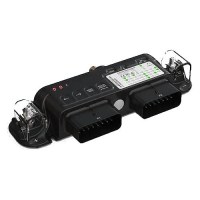
Garmin 0100271900 Livescope™ Xr - Extended Range System - 010-02719-00 - 322-0100271900F1
The latest in LiveScope technology, now for coastal and open-water fishing. Explore the deep with an extended range up to 500' in freshwater and 350' in saltwaterFind fish circling your boat with clear views close around your hullUpgrade your current LiveScope System black box (GLS™ 10 sonar module) with just a new transducerGet maximum contrast and clarity in your images with vivid color palettesdon't miss a thing with supported Forward, Down and Perspective modes plus necessary mount Includes: LiveScope GLS 10 sonar black box, LiveScope XR LVS62 transducer, Perspective mount (LiveScope XR LVS62 transducer only), Trolling motor barrel mount, Shaft mount, Power cable, 2 meter Garmin Marine Network cable (small connector) & Network adapter cable. See Garmin website for compatible fishfinders/chartplotters.
Garmin 0100273500 Boat Switch - 010-02735-00 - 322-0100273500F1
Get the integrated-boat experience with digital switching that allows you to operate onboard electrical functions right from your GPSMAP® or ECHOMAP™ chartplotter. Reduce reliance on traditional switches and fuses. Add digital control and software current monitoringSet it up your way. Position and name switches with the easy-to-use interfaceRetrofit into your boat. It requires no special tools or configuration Includes: Boat Switch, Boat Switch Harness X1 & Harness X2See Garmin website for compatible units.
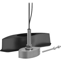
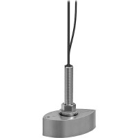
Garmin 0100276800 - 010-02768-00 - 322-0100276800F1
The Panoptix PS70 stainless steel thru-hull transducer is powered by Garmin RapidReturn™ sonar, which gives you live sonar views up to 1,000' below the surface. 800-Watt power outputImage StabilizationLive Sonar up to 1,000'. See small baitfish and target game fish in real time. The wide 120-degree beam angle covers huge areas of water.Survey areas of the ocean floor in great detail with the QuickDraw Contours feature
Garmin 0100276810 - 010-02768-10 - 322-0100276810F1
The Panoptix PS70 stainless steel thru-hull transducer is powered by Garmin RapidReturn™ sonar, which gives you live sonar views up to 1,000' below the surface. 800-Watt power outputImage StabilizationLive Sonar up to 1,000'. See small baitfish and target game fish in real time. The wide 120-degree beam angle covers huge areas of water.Survey areas of the ocean floor in great detail with the QuickDraw Contours feature
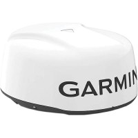
Garmin 0100284100 Gmr™ Xhd3 Radome, 18" - 010-02841-00 - 322-0100284100F1
Loaded with advanced features typically found on open arrays, these 4-kW magnetron radars © in 18" or 24" sizes © bring high-definition imaging and fast target updates to boaters who want a quiet, compact dome radar for cruising or fishing offshore. Scan averaging, a first for Garmin magnetron radar, results in reduced sea clutter and interference on the display. 4 kW of power output for up to 48 nautical mile rangeAdvanced Scan Averaging Technology filters out sea clutterRotation speeds up to 60 RPM for fast redraw ratesDual-Range overlays show close and distant radar images with split-screen view
Garmin 0100288010 Echomap™ Ultra 2 And Livescope™ Plus Bundles, 10" - 010-02880-10 - 322-0100288010F1
Designed to deliver unmatched sonar clarity, precision mapping, and seamless integration. This powerful package provides real-time sonar views of fish, structure, and your lure in stunning detail. With effortless installation and pre-configured compatibility, you'll be on the water faster and fully equipped for success. ^Includes:ECHOMAP Ultra 2 touchscreen with keyed assist chartplotterNavionics+™ maps for U.S. coastal and inland/Canada offshoreLiveScope Plus System (GLS™ 10 black box, LiveScope™ Plus LVS34 transducer, perspective mount, trolling motor barrel mount, and all required cables)20 ft. (6.1 m) Garmin Marine network cablePower cableBail mount with quick release cradleProtective sun cover8-pin transducer to 12-pin sounder adapter cableHardware and documentation
Garmin 0100288210 Echomap™ Ultra 2 And Livescope™ Plus Bundles, 12" - 010-02882-10 - 322-0100288210F1
Designed to deliver unmatched sonar clarity, precision mapping, and seamless integration. This powerful package provides real-time sonar views of fish, structure, and your lure in stunning detail. With effortless installation and pre-configured compatibility, you'll be on the water faster and fully equipped for success. ^Includes:ECHOMAP Ultra 2 touchscreen with keyed assist chartplotterNavionics+™ maps for U.S. coastal and inland/Canada offshoreLiveScope Plus System (GLS™ 10 black box, LiveScope™ Plus LVS34 transducer, perspective mount, trolling motor barrel mount, and all required cables)20 ft. (6.1 m) Garmin Marine network cablePower cableBail mount with quick release cradleProtective sun cover8-pin transducer to 12-pin sounder adapter cableHardware and documentation
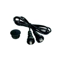
Garmin 0101055000 6' Network Cable Rj45 - 010-10550-00 - 322-0101055000F1
Marine network cable to help with install. See Garmin website for compatible devices.
Garmin 0101055100 20' Network Cable Rj45 - 010-10551-00 - 322-0101055100F1
Marine network cable to help with install. See Garmin website for compatible devices.