
Select Category
General
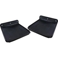
Nauticus Hd800 Hydroplane Performance Trim Tabs - Hd800 - 338-Hd800F1
For Small Boats Under 16' (10 to 40 HP)Increase top speed with hydrodynamic lift. For overall stability, faster time to plane, and elimination of common problems like porpoising and chine walking, HydroPlane provides the port-to-starboard balance that hydrofoils cannot. Installs in Minutes.

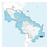
Navionics 010C136430 Navionics+ Cartography, Mexico, Caribbean To Brazil - 010-C1364-30 - 155-010C136430F1
THE NAVIONICS SUBSCRIPTION: A one-year subscription to Daily Updates and advanced features is included when you purchase any Navionics+ mapping solution. After a year, you can renew at a discounted price.CHARTS AND UPDATES:Nautical Chart - Comprehensive charts are derived from multiple official, government and private sources, displayed in a familiar look and feel.SonarChart HD Bathymetry - Innovative 1' (0.5 m) bathymetry charts are created by using Navionics proprietary systems that augment existing content with sonar data contributed by the boating community.Community Edits - Get useful local knowledge from edits made by users of the Navionics Boating app on your compatible smart device.Daily Updates - Up to 5,000 daily updates to our charts give you the most accurate, most current data availableInland Content: 42,000+ lakes (varies by coverage area)ADVANCED FEATURES:Dock-to-dock Route Guidance - Start your trip with a suggested dock-to-dock route.Advanced Map Options - Customize your view to focus on the details that matter most.Plotter Sync - Transfer routes and markers, update chart layers and more - between your compatible chartplotter and the Boating app.SonarChart Live Mapping Feature - Watch new HD depth maps develop in real time as your boat moves through the water. Visit Navionics website for full feature list, coverage details and compatibility of Navionics+ content and features with your GPS chartplotter. **NOT COMPATIBLE with GARMIN GPS chartplotters**
Navionics 010C136440 Platinum+ Cartography, Mexico, Caribbean To Brazil - 010-C1364-40 - 155-010C136440F1
THE NAVIONICS SUBSCRIPTION: A one-year subscription to Daily Updates and advanced features is included when you purchase any new Navionics Platinum+ mapping solution. After a year, you can renew at a discounted price CHARTS AND UPDATES:Nautical Chart - Comprehensive charts are derived from multiple official, government and private sources, displayed in a familiar look and feelSonarChart HD Bathymetry - Innovative 1' (0.5 m) bathymetry charts are created by using Navionics proprietary systems that augment existing content with sonar data contributed by the boating communityCommunity Edits - Get useful local knowledge from edits made by users of the Navionics Boating app on your compatible smart device.Daily Updates - Up to 5,000 daily updates to our charts give you the most accurate, most current Navionics data availableInland Content: 42,000+ lakes (varies by coverage area) ADVANCED FEATURES:Dock-to-dock Route Guidance - Start your trip with a suggested pathSonarChart Live Mapping Feature - Watch new HD depth maps develop in real time as your boat moves through the waterAdvanced Map Options - Customize your view to focus on the details that matter mostPlotter Sync - Transfer routes and markers, update chart layers and more - between your compatible chartplotter and the Boating app OVERLAYS:Relief Shading - Get an easy-to-interpret, clearer view of bottom structure. Check coverageSatellite Imagery with SonarChart Shading Overlay - Experience an enhanced awareness above and below the waterline. Check coverageSonar Imagery - View bottom hardness clearly and in contrasting color PLATINUM+ ADDITIONAL VIEWING OPTIONS:3D View - Adjust the perspective of your chart view to highlight key features and enhance awarenessAerial Photos - Get a better sense of your surroundingsVisit Navionics website for full feature list, coverage details and compatibility of Platinum+ content and features with your GPS chartplotter.**NOT COMPATIBLE with GARMIN GPS chartplotters**
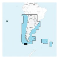
Navionics 010C136530 Navionics+ Cartography, Chile, Argentina & Easter Island - 010-C1365-30 - 155-010C136530F1
THE NAVIONICS SUBSCRIPTION: A one-year subscription to Daily Updates and advanced features is included when you purchase any Navionics+ mapping solution. After a year, you can renew at a discounted price.CHARTS AND UPDATES:Nautical Chart - Comprehensive charts are derived from multiple official, government and private sources, displayed in a familiar look and feel.SonarChart HD Bathymetry - Innovative 1' (0.5 m) bathymetry charts are created by using Navionics proprietary systems that augment existing content with sonar data contributed by the boating community.Community Edits - Get useful local knowledge from edits made by users of the Navionics Boating app on your compatible smart device.Daily Updates - Up to 5,000 daily updates to our charts give you the most accurate, most current data availableInland Content: 42,000+ lakes (varies by coverage area)ADVANCED FEATURES:Dock-to-dock Route Guidance - Start your trip with a suggested dock-to-dock route.Advanced Map Options - Customize your view to focus on the details that matter most.Plotter Sync - Transfer routes and markers, update chart layers and more - between your compatible chartplotter and the Boating app.SonarChart Live Mapping Feature - Watch new HD depth maps develop in real time as your boat moves through the water. Visit Navionics website for full feature list, coverage details and compatibility of Navionics+ content and features with your GPS chartplotter. **NOT COMPATIBLE with GARMIN GPS chartplotters**
Navionics 010C136540 Platinum+ Cartography, Chile, Argentina & Easter Island - 010-C1365-40 - 155-010C136540F1
THE NAVIONICS SUBSCRIPTION: A one-year subscription to Daily Updates and advanced features is included when you purchase any new Navionics Platinum+ mapping solution. After a year, you can renew at a discounted price CHARTS AND UPDATES:Nautical Chart - Comprehensive charts are derived from multiple official, government and private sources, displayed in a familiar look and feelSonarChart HD Bathymetry - Innovative 1' (0.5 m) bathymetry charts are created by using Navionics proprietary systems that augment existing content with sonar data contributed by the boating communityCommunity Edits - Get useful local knowledge from edits made by users of the Navionics Boating app on your compatible smart device.Daily Updates - Up to 5,000 daily updates to our charts give you the most accurate, most current Navionics data availableInland Content: 42,000+ lakes (varies by coverage area) ADVANCED FEATURES:Dock-to-dock Route Guidance - Start your trip with a suggested pathSonarChart Live Mapping Feature - Watch new HD depth maps develop in real time as your boat moves through the waterAdvanced Map Options - Customize your view to focus on the details that matter mostPlotter Sync - Transfer routes and markers, update chart layers and more - between your compatible chartplotter and the Boating app OVERLAYS:Relief Shading - Get an easy-to-interpret, clearer view of bottom structure. Check coverageSatellite Imagery with SonarChart Shading Overlay - Experience an enhanced awareness above and below the waterline. Check coverageSonar Imagery - View bottom hardness clearly and in contrasting color PLATINUM+ ADDITIONAL VIEWING OPTIONS:3D View - Adjust the perspective of your chart view to highlight key features and enhance awarenessAerial Photos - Get a better sense of your surroundingsVisit Navionics website for full feature list, coverage details and compatibility of Platinum+ content and features with your GPS chartplotter.**NOT COMPATIBLE with GARMIN GPS chartplotters**