
Select Category
General
Navionics 010C136630 Navionics+ Cartography, U.S. & Coastal Canada - 010-C1366-30 - 155-010C136630F1
THE NAVIONICS SUBSCRIPTION: A one-year subscription to Daily Updates and advanced features is included when you purchase any Navionics+ mapping solution. After a year, you can renew at a discounted price.CHARTS AND UPDATES:Nautical Chart - Comprehensive charts are derived from multiple official, government and private sources, displayed in a familiar look and feel.SonarChart HD Bathymetry - Innovative 1' (0.5 m) bathymetry charts are created by using Navionics proprietary systems that augment existing content with sonar data contributed by the boating community.Community Edits - Get useful local knowledge from edits made by users of the Navionics Boating app on your compatible smart device.Daily Updates - Up to 5,000 daily updates to our charts give you the most accurate, most current data availableInland Content: 42,000+ lakes (varies by coverage area)ADVANCED FEATURES:Dock-to-dock Route Guidance - Start your trip with a suggested dock-to-dock route.Advanced Map Options - Customize your view to focus on the details that matter most.Plotter Sync - Transfer routes and markers, update chart layers and more - between your compatible chartplotter and the Boating app.SonarChart Live Mapping Feature - Watch new HD depth maps develop in real time as your boat moves through the water. Visit Navionics website for full feature list, coverage details and compatibility of Navionics+ content and features with your GPS chartplotter. **NOT COMPATIBLE with GARMIN GPS chartplotters**
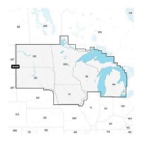
Navionics 010C136830 Navionics+ Cartography, U.S. North - 010-C1368-30 - 155-010C136830F1
THE NAVIONICS SUBSCRIPTION: A one-year subscription to Daily Updates and advanced features is included when you purchase any Navionics+ mapping solution. After a year, you can renew at a discounted price.CHARTS AND UPDATES:Nautical Chart - Comprehensive charts are derived from multiple official, government and private sources, displayed in a familiar look and feel.SonarChart HD Bathymetry - Innovative 1' (0.5 m) bathymetry charts are created by using Navionics proprietary systems that augment existing content with sonar data contributed by the boating community.Community Edits - Get useful local knowledge from edits made by users of the Navionics Boating app on your compatible smart device.Daily Updates - Up to 5,000 daily updates to our charts give you the most accurate, most current data availableInland Content: 42,000+ lakes (varies by coverage area)ADVANCED FEATURES:Dock-to-dock Route Guidance - Start your trip with a suggested dock-to-dock route.Advanced Map Options - Customize your view to focus on the details that matter most.Plotter Sync - Transfer routes and markers, update chart layers and more - between your compatible chartplotter and the Boating app.SonarChart Live Mapping Feature - Watch new HD depth maps develop in real time as your boat moves through the water. Visit Navionics website for full feature list, coverage details and compatibility of Navionics+ content and features with your GPS chartplotter. **NOT COMPATIBLE with GARMIN GPS chartplotters**

Navionics 010C136840 Platinum+ Cartography, U.S. North - 010-C1368-40 - 155-010C136840F1
THE NAVIONICS SUBSCRIPTION: A one-year subscription to Daily Updates and advanced features is included when you purchase any new Navionics Platinum+ mapping solution. After a year, you can renew at a discounted price CHARTS AND UPDATES:Nautical Chart - Comprehensive charts are derived from multiple official, government and private sources, displayed in a familiar look and feelSonarChart HD Bathymetry - Innovative 1' (0.5 m) bathymetry charts are created by using Navionics proprietary systems that augment existing content with sonar data contributed by the boating communityCommunity Edits - Get useful local knowledge from edits made by users of the Navionics Boating app on your compatible smart device.Daily Updates - Up to 5,000 daily updates to our charts give you the most accurate, most current Navionics data availableInland Content: 42,000+ lakes (varies by coverage area) ADVANCED FEATURES:Dock-to-dock Route Guidance - Start your trip with a suggested pathSonarChart Live Mapping Feature - Watch new HD depth maps develop in real time as your boat moves through the waterAdvanced Map Options - Customize your view to focus on the details that matter mostPlotter Sync - Transfer routes and markers, update chart layers and more - between your compatible chartplotter and the Boating app OVERLAYS:Relief Shading - Get an easy-to-interpret, clearer view of bottom structure. Check coverageSatellite Imagery with SonarChart Shading Overlay - Experience an enhanced awareness above and below the waterline. Check coverageSonar Imagery - View bottom hardness clearly and in contrasting color PLATINUM+ ADDITIONAL VIEWING OPTIONS:3D View - Adjust the perspective of your chart view to highlight key features and enhance awarenessAerial Photos - Get a better sense of your surroundingsVisit Navionics website for full feature list, coverage details and compatibility of Platinum+ content and features with your GPS chartplotter.**NOT COMPATIBLE with GARMIN GPS chartplotters**
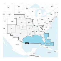
Navionics 010C136930 Navionics+ Cartography, U.S. South - 010-C1369-30 - 155-010C136930F1
THE NAVIONICS SUBSCRIPTION: A one-year subscription to Daily Updates and advanced features is included when you purchase any Navionics+ mapping solution. After a year, you can renew at a discounted price.CHARTS AND UPDATES:Nautical Chart - Comprehensive charts are derived from multiple official, government and private sources, displayed in a familiar look and feel.SonarChart HD Bathymetry - Innovative 1' (0.5 m) bathymetry charts are created by using Navionics proprietary systems that augment existing content with sonar data contributed by the boating community.Community Edits - Get useful local knowledge from edits made by users of the Navionics Boating app on your compatible smart device.Daily Updates - Up to 5,000 daily updates to our charts give you the most accurate, most current data availableInland Content: 42,000+ lakes (varies by coverage area)ADVANCED FEATURES:Dock-to-dock Route Guidance - Start your trip with a suggested dock-to-dock route.Advanced Map Options - Customize your view to focus on the details that matter most.Plotter Sync - Transfer routes and markers, update chart layers and more - between your compatible chartplotter and the Boating app.SonarChart Live Mapping Feature - Watch new HD depth maps develop in real time as your boat moves through the water. Visit Navionics website for full feature list, coverage details and compatibility of Navionics+ content and features with your GPS chartplotter. **NOT COMPATIBLE with GARMIN GPS chartplotters**
Navionics 010C136940 Platinum+ Cartography, U.S. South - 010-C1369-40 - 155-010C136940F1
THE NAVIONICS SUBSCRIPTION: A one-year subscription to Daily Updates and advanced features is included when you purchase any new Navionics Platinum+ mapping solution. After a year, you can renew at a discounted price CHARTS AND UPDATES:Nautical Chart - Comprehensive charts are derived from multiple official, government and private sources, displayed in a familiar look and feelSonarChart HD Bathymetry - Innovative 1' (0.5 m) bathymetry charts are created by using Navionics proprietary systems that augment existing content with sonar data contributed by the boating communityCommunity Edits - Get useful local knowledge from edits made by users of the Navionics Boating app on your compatible smart device.Daily Updates - Up to 5,000 daily updates to our charts give you the most accurate, most current Navionics data availableInland Content: 42,000+ lakes (varies by coverage area) ADVANCED FEATURES:Dock-to-dock Route Guidance - Start your trip with a suggested pathSonarChart Live Mapping Feature - Watch new HD depth maps develop in real time as your boat moves through the waterAdvanced Map Options - Customize your view to focus on the details that matter mostPlotter Sync - Transfer routes and markers, update chart layers and more - between your compatible chartplotter and the Boating app OVERLAYS:Relief Shading - Get an easy-to-interpret, clearer view of bottom structure. Check coverageSatellite Imagery with SonarChart Shading Overlay - Experience an enhanced awareness above and below the waterline. Check coverageSonar Imagery - View bottom hardness clearly and in contrasting color PLATINUM+ ADDITIONAL VIEWING OPTIONS:3D View - Adjust the perspective of your chart view to highlight key features and enhance awarenessAerial Photos - Get a better sense of your surroundingsVisit Navionics website for full feature list, coverage details and compatibility of Platinum+ content and features with your GPS chartplotter.**NOT COMPATIBLE with GARMIN GPS chartplotters**
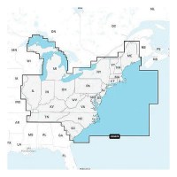
Navionics 010C137030 Navionics+ Cartography, U.S. East - 010-C1370-30 - 155-010C137030F1
THE NAVIONICS SUBSCRIPTION: A one-year subscription to Daily Updates and advanced features is included when you purchase any Navionics+ mapping solution. After a year, you can renew at a discounted price.CHARTS AND UPDATES:Nautical Chart - Comprehensive charts are derived from multiple official, government and private sources, displayed in a familiar look and feel.SonarChart HD Bathymetry - Innovative 1' (0.5 m) bathymetry charts are created by using Navionics proprietary systems that augment existing content with sonar data contributed by the boating community.Community Edits - Get useful local knowledge from edits made by users of the Navionics Boating app on your compatible smart device.Daily Updates - Up to 5,000 daily updates to our charts give you the most accurate, most current data availableInland Content: 42,000+ lakes (varies by coverage area)ADVANCED FEATURES:Dock-to-dock Route Guidance - Start your trip with a suggested dock-to-dock route.Advanced Map Options - Customize your view to focus on the details that matter most.Plotter Sync - Transfer routes and markers, update chart layers and more - between your compatible chartplotter and the Boating app.SonarChart Live Mapping Feature - Watch new HD depth maps develop in real time as your boat moves through the water. Visit Navionics website for full feature list, coverage details and compatibility of Navionics+ content and features with your GPS chartplotter. **NOT COMPATIBLE with GARMIN GPS chartplotters**
Navionics 010C137040 Platinum+ Cartography, U.S. East - 010-C1370-40 - 155-010C137040F1
THE NAVIONICS SUBSCRIPTION: A one-year subscription to Daily Updates and advanced features is included when you purchase any new Navionics Platinum+ mapping solution. After a year, you can renew at a discounted price CHARTS AND UPDATES:Nautical Chart - Comprehensive charts are derived from multiple official, government and private sources, displayed in a familiar look and feelSonarChart HD Bathymetry - Innovative 1' (0.5 m) bathymetry charts are created by using Navionics proprietary systems that augment existing content with sonar data contributed by the boating communityCommunity Edits - Get useful local knowledge from edits made by users of the Navionics Boating app on your compatible smart device.Daily Updates - Up to 5,000 daily updates to our charts give you the most accurate, most current Navionics data availableInland Content: 42,000+ lakes (varies by coverage area) ADVANCED FEATURES:Dock-to-dock Route Guidance - Start your trip with a suggested pathSonarChart Live Mapping Feature - Watch new HD depth maps develop in real time as your boat moves through the waterAdvanced Map Options - Customize your view to focus on the details that matter mostPlotter Sync - Transfer routes and markers, update chart layers and more - between your compatible chartplotter and the Boating app OVERLAYS:Relief Shading - Get an easy-to-interpret, clearer view of bottom structure. Check coverageSatellite Imagery with SonarChart Shading Overlay - Experience an enhanced awareness above and below the waterline. Check coverageSonar Imagery - View bottom hardness clearly and in contrasting color PLATINUM+ ADDITIONAL VIEWING OPTIONS:3D View - Adjust the perspective of your chart view to highlight key features and enhance awarenessAerial Photos - Get a better sense of your surroundingsVisit Navionics website for full feature list, coverage details and compatibility of Platinum+ content and features with your GPS chartplotter.**NOT COMPATIBLE with GARMIN GPS chartplotters**
Navionics 010C137130 Navionics+ Cartography, U.S. West - 010-C1371-30 - 155-010C137130F1
THE NAVIONICS SUBSCRIPTION: A one-year subscription to Daily Updates and advanced features is included when you purchase any Navionics+ mapping solution. After a year, you can renew at a discounted price.CHARTS AND UPDATES:Nautical Chart - Comprehensive charts are derived from multiple official, government and private sources, displayed in a familiar look and feel.SonarChart HD Bathymetry - Innovative 1' (0.5 m) bathymetry charts are created by using Navionics proprietary systems that augment existing content with sonar data contributed by the boating community.Community Edits - Get useful local knowledge from edits made by users of the Navionics Boating app on your compatible smart device.Daily Updates - Up to 5,000 daily updates to our charts give you the most accurate, most current data availableInland Content: 42,000+ lakes (varies by coverage area)ADVANCED FEATURES:Dock-to-dock Route Guidance - Start your trip with a suggested dock-to-dock route.Advanced Map Options - Customize your view to focus on the details that matter most.Plotter Sync - Transfer routes and markers, update chart layers and more - between your compatible chartplotter and the Boating app.SonarChart Live Mapping Feature - Watch new HD depth maps develop in real time as your boat moves through the water. Visit Navionics website for full feature list, coverage details and compatibility of Navionics+ content and features with your GPS chartplotter. **NOT COMPATIBLE with GARMIN GPS chartplotters**
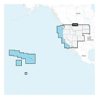
Navionics 010C137140 Platinum+ Cartography, U.S. West - 010-C1371-40 - 155-010C137140F1
THE NAVIONICS SUBSCRIPTION: A one-year subscription to Daily Updates and advanced features is included when you purchase any new Navionics Platinum+ mapping solution. After a year, you can renew at a discounted price CHARTS AND UPDATES:Nautical Chart - Comprehensive charts are derived from multiple official, government and private sources, displayed in a familiar look and feelSonarChart HD Bathymetry - Innovative 1' (0.5 m) bathymetry charts are created by using Navionics proprietary systems that augment existing content with sonar data contributed by the boating communityCommunity Edits - Get useful local knowledge from edits made by users of the Navionics Boating app on your compatible smart device.Daily Updates - Up to 5,000 daily updates to our charts give you the most accurate, most current Navionics data availableInland Content: 42,000+ lakes (varies by coverage area) ADVANCED FEATURES:Dock-to-dock Route Guidance - Start your trip with a suggested pathSonarChart Live Mapping Feature - Watch new HD depth maps develop in real time as your boat moves through the waterAdvanced Map Options - Customize your view to focus on the details that matter mostPlotter Sync - Transfer routes and markers, update chart layers and more - between your compatible chartplotter and the Boating app OVERLAYS:Relief Shading - Get an easy-to-interpret, clearer view of bottom structure. Check coverageSatellite Imagery with SonarChart Shading Overlay - Experience an enhanced awareness above and below the waterline. Check coverageSonar Imagery - View bottom hardness clearly and in contrasting color PLATINUM+ ADDITIONAL VIEWING OPTIONS:3D View - Adjust the perspective of your chart view to highlight key features and enhance awarenessAerial Photos - Get a better sense of your surroundingsVisit Navionics website for full feature list, coverage details and compatibility of Platinum+ content and features with your GPS chartplotter.**NOT COMPATIBLE with GARMIN GPS chartplotters**
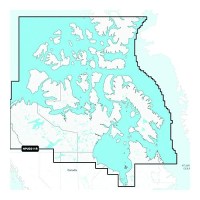
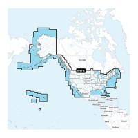
Navionics+ 010-C146230 Canada North Chart - 010-C1462-30 - 155-010C146230F1
Navionics+ Canada, Canada North-Lakes, Rivers and Coastal Marine Chart. Includes a one-year subscription to Daily Updates and advanced features. After a year, renew at a discounted priceVisit Navionics website for full feature list, coverage details and compatibility of Navionics+ content and features with your GPS chartplotter.**NOT COMPATIBLE with GARMIN GPS chartplotters*
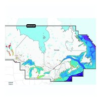
Navionics+ 010-C146630 Canada, East & Great Lakes Chart - 010-C1466-30 - 155-010C146630F1
Navionics+ Canada, East & Great Lakes -Lakes, Rivers and Coastal Marine Chart. Includes a one-year subscription to Daily Updates and advanced features. After a year, renew at a discounted priceVisit Navionics website for full feature list, coverage details and compatibility of Navionics+ content and features with your GPS chartplotter.**NOT COMPATIBLE with GARMIN GPS chartplotters*
Navionics+ 010-C146640 Platinum+Canada, East & Great Lakes Chart - 010-C1466-40 - 155-010C146640F1
Navionics Platinum+ Canada, East & Great Lakes -Lakes, Rivers and Coastal Marine Chart. Platinum+ additinal features include: High resolution relief shading and satellite imagery, sonar imagery, aerial photography and 3D view.Includes a one-year subscription to Daily Updates and advanced features. After a year, renew at a discounted price.Visit Navionics website for full feature list, coverage details and compatibility of Navionics+ content and features with your GPS chartplotter.**NOT COMPATIBLE with GARMIN GPS chartplotters*
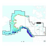
Navionics+ 010-C146730 Canada, West & Alaska Chart - 010-C1467-30 - 155-010C146730F1
Navionics+ Canada, West & Alaska -Lakes, Rivers and Coastal Marine Chart. Includes a one-year subscription to Daily Updates and advanced features. After a year, renew at a discounted priceVisit Navionics website for full feature list, coverage details and compatibility of Navionics+ content and features with your GPS chartplotter.**NOT COMPATIBLE with GARMIN GPS chartplotters*
Navionics+ 010-C146740 Platinum+ Canada, West & Alaska Chart - 010-C1467-40 - 155-010C146740F1
Navionics Platinum+ Canada, West & Alaska -Lakes, Rivers and Coastal Marine Chart. Platinum+ additional features include: High resolution relief shading and satellite imagery, sonar imagery, aerial photography and 3D view.Includes a one-year subscription to Daily Updates and advanced features. After a year, renew at a discounted price.Visit Navionics website for full feature list, coverage details and compatibility of Navionics+ content and features with your GPS chartplotter.**NOT COMPATIBLE with GARMIN GPS chartplotters*
Navy Double Braid, 3/8" X 600' - 47060 - 50-47060F1
Excellent high grade nylon. Long wearing and resists kinking. Can be used to make dock, anchor and mooring lines.
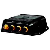
Nep-2 Network Expansion Port - 000-10029-001 - 149-00010029001F1
Expands ethernet network connectivity for multiple displays and modules.
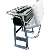
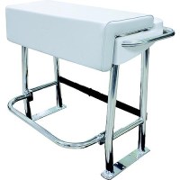
Neptune Ii Leaning Post - L10-1003-1 - 236-L1010031F1
Polished anodized aluminum pipe construction Soft removable under-seat storage tote4 welded-in rod holdersAdjustable footrestUpholstered cushion seat and under-seat storageWeather-resistant, upholstered, padded vinyl seat always looks new3-year warranty.Breaks down to UPS'able packageFootprint: 15" x 35"
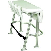
Neptune Iii Standard Leaning Post - L10-2005Bsa-1 - 236-L102005Bsa1F1
Designed with the fishing enthusiast in mind, the four rod holders on the Neptune III Leaning Post are the perfect helm support for carrying multiple rods in center console boats 25' and under. Its practical, smooth upholstery design features an anodized aluminum frame, a folding footrest and a large under-seat storage space for coolers or tackle boxes. Rod holders sit at a 15° angle. Mildew, fungus and UV-resistant marine-grade vinyl fabric. Storage space for a 72-quart cooler, which secures in place using a strap (included). 3-year limited warranty.
Neptune Premium Leaning Post - L10-1001-1 - 236-L1010011F1
Breaks down to UPS'able packageDim. (w/o backrest): 27" L x 39" W x 31-1/2" H Dim. (w/backrest): 27" L x 39" W x 49" H